Mao: OS Explorer OL30 Yorkshire Dales (Northern and Central). Start: Gunnerside (limited parking near village hall). Distance: about 9 miles, goes to quiet a height over moors, so can be dodgy in wet or misty weather. Pubs: Farmer's Arms, Muker and King's Head, Gunnerside.
This is another that has the lot - two of Swaledale's most attractive villages, the often eerie remains of lead mining, a bleak moor top, a remote valley and a smashing pub.Park with consideration in Gunnerside and leave the village on the signed footpath alongside the right (east) bank of Gunnerside Gill. Follow this path for more than two miles as the Gill becomes more and more wild, eventually finishing up alongside the beck next to some remains of buildings. Cross the slab bridge and turn left, sloping up the bank on a path that becomes a track as it approaches a sharp right turn to cross a side stream.
Turn right before crossing the stream and climb roughly north west towards some lead mine spoil heaps in the distance, passing a shooting box on the way. Stay with the track and look out for two small ponds over to the left, Moss Dam.
Stick with this track all the way as it begins to descend near the source of Swinner Gill, another of the many tributaries of the Swale in these parts. Keep the Gill to your left and do not cross it, even when you see the track heading south, which is the direction you need – but not until later. This track comes out high above the Swale and when we last tried it, had been washed away as it crossed a small side-stream and two of our intrepid band had to scramble down dangerous screes to reach the River, much to the amusement of their “friends.”
Instead, keep Swinner Gill on your left and follow it down a difficult path, passing some lead mining remains and following the sign for Keld rather than the hairy route to Muker.
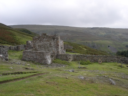 Go round the ruins of Crackpot Hall (left), and turn left to descend to the Swale, where a bridge lets you cross Swinner Gill as you head south alongside the river. This beautiful section of the walk is a bit of a rarity in the Yorkshire Dales – a section of one of the main rivers without a road running alongside it. The road has taken another route and meets up with the river again upstream at Keld.
It’s not far short of two miles before you cross the Swale on a footbridge and follow the path across half a dozen fields into Muker and the Farmer’s Arms. If it’s wet and cold, the fire’s a welcome site, and if the weather’s fine, sitting outside is just as good.
Either way, the beer’s well-kept. So well kept that leaving can be hard work, but when you do, leave the village the same way as you came in, turning right after crossing the footbridge before following the Swale to the incredible Ivelet Bridge more than a mile downstream.
Follow the minor road as it climbs into Ivelet, turn right at the crossroads (Piccadilly Circus it ain’t) and look for the footpath that crosses a small, deep valley by footbridge. When you emerge, follow the footpath across several fields before you have to make a decision … back to Gunnerside across more fields, or via the riverside path that emerges at Gunnerside Bridge, where you turn left and follow the road into the village.
For us, the riverside route is the better one.